Written by Alex Jones, Ph.D. candidate at Imperial College London After a busy few months exploring the outer slopes of the Jezero crater rim at an area named “Witch Hazel Hill,” the Perseverance Science Team was eyeing another sample of these truly ancient rocks, which likely predate Jezero crater itself. The target? A rock containing […]...
2 min read
A Tough Drill at Witch Hazel Hill

The Bell Island drill hole: This image of the Bell Island drill hole was acquired by the front left Hazcam, on May 7, 2025 (Sol 1497, or Martian day 1,497 of the Mars 2020 mission) at the local mean solar time of 15:31:16.
NASA/JPL-Caltech
Written by Alex Jones, Ph.D. candidate at Imperial College London
After a busy few months exploring the outer slopes of the Jezero crater rim at an area named “Witch Hazel Hill,” the Perseverance Science Team was eyeing another sample of these truly ancient rocks, which likely predate Jezero crater itself.
The target? A rock containing spherules, which could shed a light on volcanic- or impact-related processes occurring in Mars’ most ancient past. After a search of several outcrops, the “Hare Bay” abrasion patch at “Pine Pond” revealed suitably accessible and spherule-bearing bedrock for sampling.
On Sol 1483 of the mission, sampling was a-go… But Mars wasn’t keen to give its secrets away too easily.
As data began arriving on Earth, it became clear Perseverance had managed to drill into the rock but had stopped short of retracting the drill and storing the sample. It transpired that this rock was particularly hard — a far cry from the crumbly rocks of the upper crater rim that fell apart when faced with Perseverance’s drill bit.
This isn’t the first time a hard rock has gotten in the way of sampling; an extremely hard-to-crack boulder on the Jezero fan top stopped the drill short. This time though, the drill penetrated the rock as expected, but faulted during retraction. After a few sols of hard work by the engineering team, however, there were smiles all round as images of the successfully retracted drill reached Earth.
But Mars wasn’t finished with surprises yet.
The “Bell Island” core contained the spherules the team were looking for, but the sample tube was overfilled. This meant that excess core length would prevent the sample from being sealed. In the end, the team opted to execute a dump activity to clear at least some of the sample out of the tube. This activity succeeded in removing enough sample that the tube can now be sealed in the future. As has been the case in the past on Mars, the most exciting discoveries often require a little Perseverance…


before
during
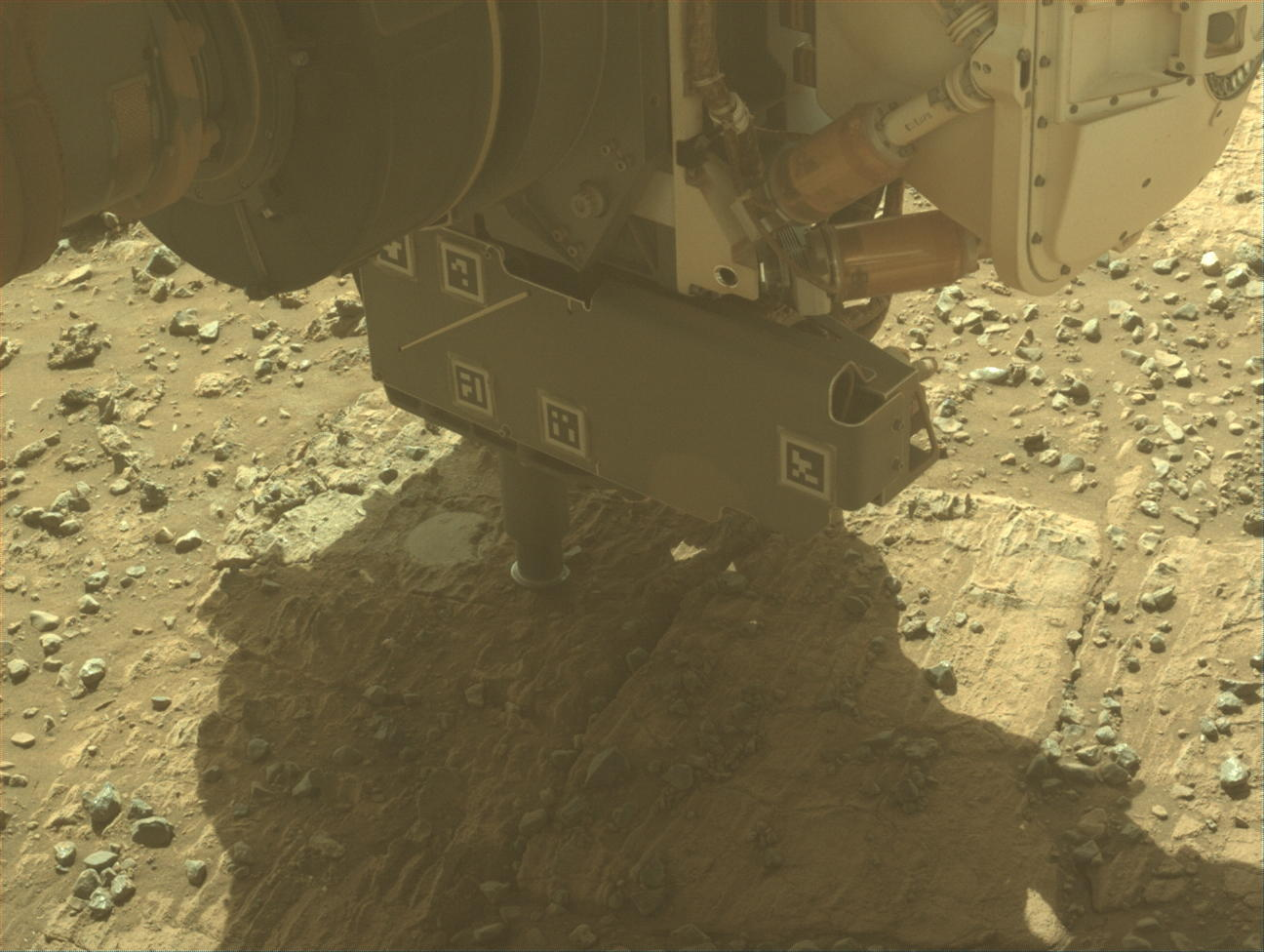
Sampling the spherules: The first image (left) shows Perseverance placing its stabilizers, ready to drill into the layered, spherule-bearing bedrock at the local mean solar time of 15:19:19 on April 22, 2025 (Sol 1483).
NASA/JPL-Caltech
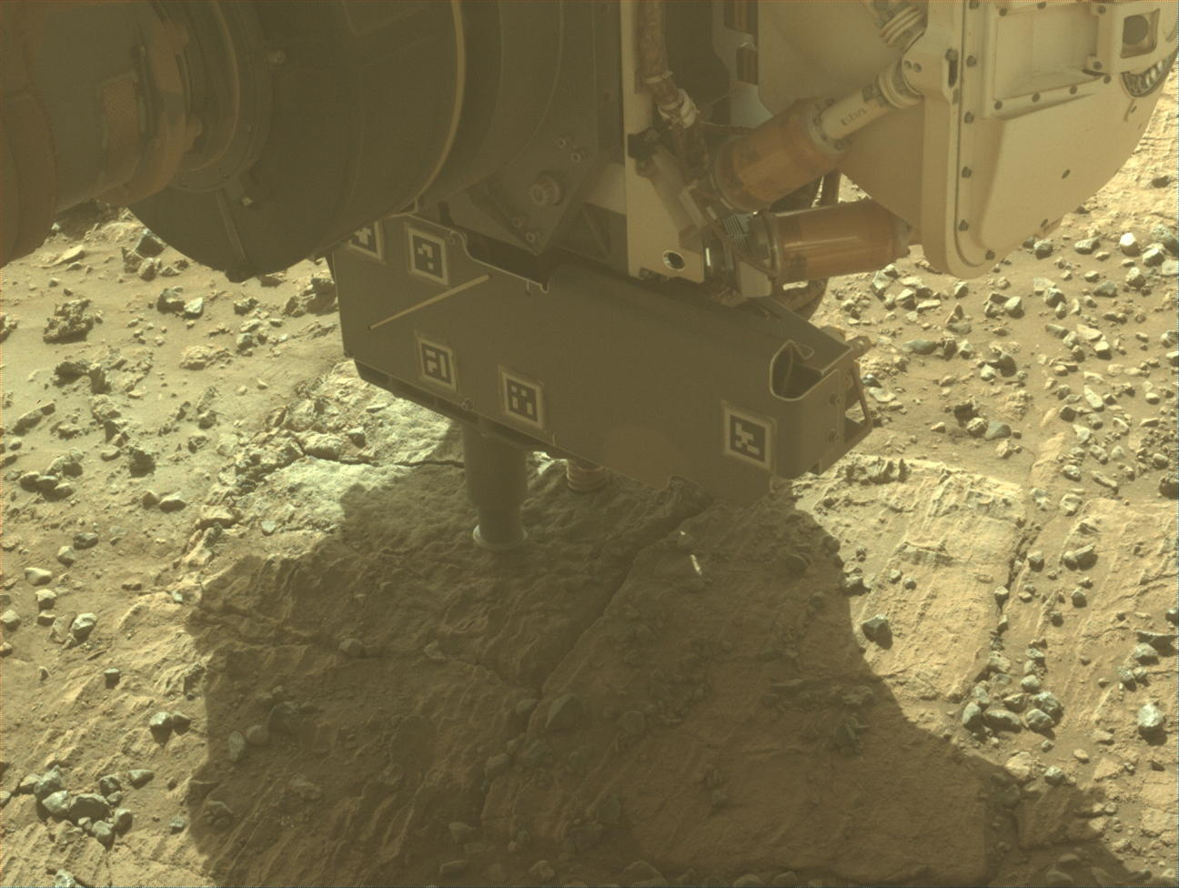
Sampling the spherules: The second image (right), acquired approximately 25 minutes later, shows Perseverance’s drill embedded into the rock, having covered the Hare Bay abrasion patch with rock powder during the drilling process. Several pebbles (most notably in the lower left) appear to have moved between the first and second image, due to vibrations caused by the drilling. Both images were acquired by the rover’s front left Hazcam.
NASA/JPL-Caltech
Sampling the spherules: The first image (left) shows Perseverance placing its stabilizers, ready to drill into the layered, spherule-bearing bedrock at the local mean solar time of 15:19:19 on April 22, 2025 (Sol 1483).
NASA/JPL-Caltech
Sampling the spherules: The second image (right), acquired approximately 25 minutes later, shows Perseverance’s drill embedded into the rock, having covered the Hare Bay abrasion patch with rock powder during the drilling process. Several pebbles (most notably in the lower left) appear to have moved between the first and second image, due to vibrations caused by the drilling. Both images were acquired by the rover’s front left Hazcam.
NASA/JPL-Caltech
before
during
ready, set, drill
Sampling the Spherules
April 22, 2025
The first image (left) shows Perseverance placing its stabilizers, ready to drill into the layered, spherule-bearing bedrock at the local mean solar time of 15:19:19 on April 22, 2025 (Sol 1483). The second image (right), acquired approximately 25 minutes later, shows Perseverance’s drill embedded into the rock, having covered the Hare Bay abrasion patch with rock powder during the drilling process. Several pebbles (most notably in the lower left) appear to have moved between the first and second image, due to vibrations caused by the drilling. Both images were acquired by the rover’s front left Hazcam.
Share
Details
Last Updated
May 14, 2025